
International Conference of Indonesia Society for Remote SensingÂ
3rd ICOIRS 2017  –  PIT MAPIN XXIV
Topics & Scopes
3rd ICOIRS 2017 that collaborate with Indonesian Society for Remote Sensing (ISRS/MAPIN), PUI – PKMBRP (Center of Excellent for Science and Technology – Center for Coastal Mitigation and Rehabilitation Studies) Diponegoro University, PUI – PPPJ (Center of Excellent for Science and Technology – Center for Utilization of Remote Sensing) Indonesian National Institute of Aeronautics and Space and BIG (Geospatial Information Agency) are proudly to organize an International Conference on Remote Sensing for global cooperation to conserving the earth. It is estimated that around 150 papers from international participants will be presented.
The previous event (the 2nd ICOIRS 2016, in Yogyakarta, Indonesia) has been successfully organized with over 100 papers from several countries. This conference is backed by prominent scientists and scholars that serve as scientific committee and reviewers who help to maintain the standard of technical publication.
Paper Scope
The scope of Remote Sensing encompasses publications with topics:
Sensor and Platform
Sensor
• Optical
• Microwave
• Lidar and others
Platform
• Satellite
• Airborne
• Unmanned aerial vehicle (UAV)
Method development and Image Processing
•  Change Detection
•  Classification
•  Feature Extraction
•  Data Fusion and Data Mining
•  Calibration and Registration
•  3D Modeling
•  Data Compression
•  Microwave and Lidar Proccessing
•  Synthetic-aperture radar (SAR) and Interferometric Synthetic Aperture Radar (InSAR) Processing
Environmental Science
•  Earth Observation
•  Climate Change
•  Oceanography
•  Oil Spillage Monitoring
•  Ecology and Conservation
•  Archeology and Culture Heritage
•  Geology, Geography, and Geomorphology
•  Cryosphere
Natural Resources
•  Oceanography
•  Land Cover and Land use
•  Forestry
•  Agriculture, Soil, and Crop
•  Land use cover change
•  Mining analysis and development
•  Urban development and planning
•  Plantation analysis and development
•  Sustainable fisheries
Coastal and Marine
•  Coastal Disaster Mitigation and Rehabilitation
•  Fisheries and Aquaculture
•  Integration of Remote Sensing and Ocean Modeling
•  Shallow Waters Habitat Mapping
•  Coastal and Ocean Spatial Planning
•  Marine Cadaster
Hazards
•  Flood/Drought
•  Tsunami
•  Earthquake
•  Landslide
•  Forest Fire
•  Volcanoe
•  Ocean hazards aspects
Social Economic Science and Policy
•  Green economic development using Remote sensing
•  Sustainable spatial planning development using Remote sensing
•  Remote Sensing for accelerating development planning
•  Food security
•  Natural resources accounting based on Remote sensing
Health Science
•  Geospatial Technology for Energy and Health Care.
•  Geospatial Technology for Social Sciences
•  Legal, Ethical and Social Issues
Education
•  Capacity Building, Education, and Training
•  Outreach
Geographic Information Systems (GIS)
•  Spatial Database and Analysis
•  GIS modeling for special purposes assessment
•  Integrated Remote sensing and GIS analysis
•  Data Quality and Spatial Standard
•  Decision Support and Modeling
•  Visualization and Communication
•  Service-oriented architecture (SOA) and Cloud Computing
•  Web Map Service
•  Mobile GIS
Mapping and Geospatial Information
•  Geospatial development supported by Remote sensing
•  Mobile Mapping
•  Photogrammetry and Surveying
•  Digital Photogrammetry
•  Digital Elevation Modeling
•  Space Program
•  Spatial data Infrastructure development and network
•  International Cooperation
GPS and Global Navigation Satellite Systems
•  Global Positioning System (GPS) application
•  Navigation
•  Location-Based Service
Keynote Speakers
1. Prof. Dr. Ir Hasanuddin Zainal Abiddin, M.Sc (Head of Indonesian Geospatial Information Agency, Indonesia).
2. Dr. Orbita Roswintiarti M.Sc (Deputy Chairman of Remote Sensing Affairs, Indonesian National Institute of Aeronautics and Space, Indonesia).
3. Prof. M. Lesturge, ONERA (MIMO Radar and Waveform Design, France) – (Under Confirmation)
4. Dr. P. Rosen, JPL (National Aeronautics and Space Administration, USA).
5. Lal Samarakun, Ph.D (Director of Geoinformatics Center, AIT, Thailand).
6. Prof. Dr. Ir. Muhammad Zainuri, M.Sc (Center of Excellent for Science and Technology, Center for Coastal Hazard Mitigation and Rehabilitation Studies, LPPM Diponegoro University, Indonesia).
7. Prof. Dr. Ir. Dewayani Sutrisno, M.Sc (President of Indonesian Society for Remote Sensing, Indonesia)
Important Dates

Author Guidelines
Author guidelines determine by two difference part as below :
1. Paper Submitted for IOP Conference Proceeding (Confirmation)
2. Paper Submitted for 3th ICOIRS 2017 – PIT MAPIN XXIV Proceeding (Indonesia ISBN)
3. Selected Paper will be published on special edition of “Biotropia” (The Southeast Asian Journal of Tropical Biology)
4. Selected paper will be published on National Journal of Geospatial Information Agency
Registration Fees
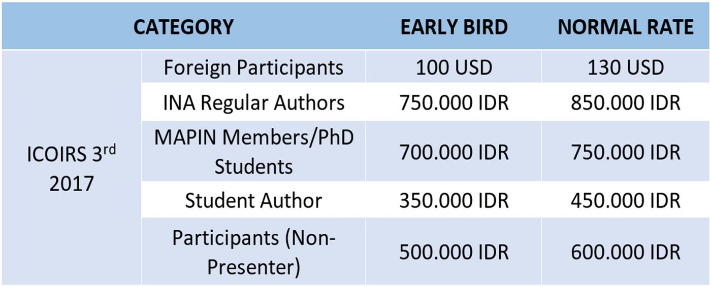
•  Additional papers under the same authors: 50% normal rate/papers (max 3 papers)
•  The Conference fee does NOT INCLUDE accommodation, Central Java Tour, Training course and workshop.
Registration fee for 3th ICOIR 2017 must be transfered to:
• IDR
Masyarakat Ahli Penginderaan Jauh Indonesia (MAPIN)
Bank Negara Indonesia Bogor Branch
Jln. Ir. H.Djuanda Bogor
Rec No : 0275326621
Swift Code: BNINIDJABGR
• USD
Masyarakat Ahli Penginderaan Jauh Indonesia(MAPIN)
Bank Negara Indonesia Bogor Branch
Jln. Ir. H. Djuanda Bogor
Rec No: 025745 3016
Swift Code: BNINIDJABGR
Paper Submitted to 3th ICOIRS 2017 ProceedingÂ
Full text paper of abstract should be prepared using MS Word document according to the following template.
To submit abstract for the conference, please download the following abstract template and complete the online Abstract Submission Form.
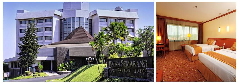
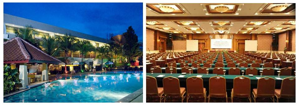
Venue
Patra Semarang Hotel & Convention
Address
Jl. Sisingamangaraja, Candi Baru, Wonotingal, Candisari, Kota Semarang
Provinsi Jawa Tengah 50252, Phone +62 024 8414141
Location
Booking Hotel
Significant discount would be available for the each participant of the International Joint Conference of Indonesian Society for Remote Sensing (PIT MAPIN XXIV) 2017. Pembayaran dapat dilakukan secara langsung kepada Patra Semarang Hotel & Convention dengan menunjukkan print / scanned file bukti telah melakukan registrasi.
About Semarang
History
In 1678, Sunan Amangkurat II promised to give control of Semarang to the Dutch East India Company (VOC) as a part of a debt payment. In 1682, the Semarang state was founded by the Dutch colonial power. On 5 October 1705 after years of occupations, Semarang officially became a VOC city when Susuhunan Pakubuwono I made a deal to give extensive trade rights to the VOC in exchange of wiping out Mataram’s debt. The VOC, and later, the Dutch East Indies government, established tobacco plantations in the region and built roads and railroads, making Semarang an important colonial trading centre.
Classical Indische Town (1678–1870)
Semarang was handed by the Sultan of Mataram to the Dutch East Indies in 1678. The city was pictured as a small settlement with a pious Muslim area called Kauman, a Chinese quarter, and a Dutch fortress. The fortress has a pentagonal form with only one gate in the south and five monitoring towers to protect the Dutch settlement from rebellion actions, segregating the spaces between Dutch settlement and other areas. In fact, the city of Semarang was only referred to the Dutch quarter while the other ethnic settlement were considered as villages outside the city boundary. The city, known as de Europeesche Buurt, was built in classical European style with church located in the centre, wide boulevards and streets skirted by beautiful villas.
The Modern City (1870–1922)
Old locomotive next to the Lawang Sewu building improved communication, as the result of the Mail and Railway projects, had brought an economic booming for the city in the 1870s. There were hospital, churches, hotels, and large houses built along the new main roads; Bojongscheweg, Pontjolscheweg, and Mataram street, causing denser population in the ethnic settlements and creating the urban kampong.
Japanese Occupation and Early Independence
The Japanese military occupied the city, along with the rest of Java, in 1942, during the Pacific War of World War II. During that time, Semarang was headed by a military governor called a Shiko, and two vice governors known as Fuku Shiko. One of the vice governors was appointed from Japan, and the other was chosen from the local population. After Indonesian independence in 1945, Semarang became the capital of Central Java province.
How to Get In
![]() Â By plane
 By plane
Semarang’s Airport is Achmad Yani International Airport, quite nearby from the city centre. Daily flights are available to Singapore, Malaysia, and many major cities in Indonesia.
![]() By train
By train
Semarang is connected to Jakarta, Bandung and Surabaya by train. There are two main railway stations in Semarang, Stasiun Tawang and Stasiun Poncol.
![]() By car
By car
Semarang can be reached by car from Jakarta. It takes around 10 to 12 hours depending on traffic. Gas stations are abundant, you can see them almost every 5 or 10 kilometres along the road.
![]() By bus
By bus
Many bus companies offer daily service to Semarang. You can choose to go in the day time with air conditioner and overnight bus with air conditioner are also available with good services
People and Culture
Javanese culture is the culture of the Javanese ethnic group which one of it is there in Central Java Province. Due to various migrations, The migrants bring with them various aspect of Javanese cultures such as Gamelan music, traditional dances and art of Wayang kulit shadow play. In Javanese, traditionally, most Javanese are farmers. This was especially common because of the fertile volcanic soil in Java. Batik is traditionally done as a past time activity for women. But some town and villages have specialized in making Batik, such as Pekalongan and Semarang.
Cuisine
Javanese cuisine and culture place an important role in rice, the staple food of the island. Central Javanese cuisine prefer sweeter foods. The most common meal ingredients are rice, stir-fried vegetables, dried salted fish, tofu, tempe (a bar of fermented soybeans), fish or shrimp crackers, and (chili sauce). Favorite dishes include gado-gado (a salad of partially boiled vegetables eaten with a peanut sauce), sayur lodeh (a vegetable and coconut milk stew), perkedel (fat potato fritters), and soto (soup with chicken, noodles, and other ingredients). Common desserts are gethuk (a steamed cassava dish colored pink, green, or white) and various sticky-rice preparations (jenang dodol, klepon, and wajik).